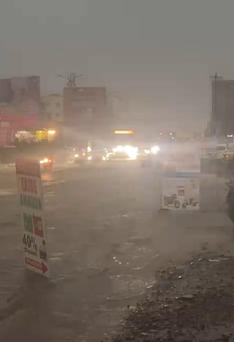
Pune: City experienced its most intense rainfall of the season on Friday evening, with Shivajinagar logging 55 mm of precipitation in under three hours. The heavy showers, accompanied by thunder and lightning, led to extensive waterlogging and severe traffic snarls throughout the city.
According to data from the India Meteorological Department (IMD), all major monitoring stations in Pune reported significant rainfall. Chinchwad recorded 47.5 mm, Lohegaon 45 mm, and Magarpatta 40.5 mm. Lavale saw 38.5 mm, while NDA and Koregaon Park received 10.5 mm and 0.5 mm respectively by 8:30 pm.
The downpour brought city traffic to a grinding halt, turning main roads into streams and prolonging commute times significantly. “I started from Wagholi at 6 pm for Hadapsar—a journey that usually takes 45 minutes—but I reached at 9.30 pm due to waterlogging and standstill traffic,” shared one commuter.
The worst-hit areas included Ivy Estate Road in Wagholi and certain pockets of Undri. The Hadapsar-Kharadi bypass was also heavily congested due to stagnant water on the roads.
The IMD has issued a red alert for extremely heavy rainfall in coastal districts like Ratnagiri, Sindhudurg, and Raigad. Pune and several other regions in Maharashtra remain under an orange alert, with forecasts predicting continued rainfall, accompanied by thunderstorms, over the coming days.
Different districts in Maharashtra are expected to receive varying rain intensities. Kolhapur is forecasted to get heavy rainfall in isolated areas, while Jalgaon may experience light to moderate rain with thunder. Thunderstorms and lightning are likely in some parts of Nashik as well.
A national bulletin released by the IMD on Friday mentioned that regions in Madhya Maharashtra, Marathwada, and Gujarat will likely experience light to moderate rainfall and thunderstorms from June 13 to 17. Very heavy rainfall is anticipated in Konkan and Goa on June 17, with Madhya Maharashtra also expected to see intense showers between June 15 and 17. Rainfall exceeding 200 mm in 24 hours is predicted in parts of Konkan and Goa until June 16.
An IMD official explained the deluge as a result of three interacting weather systems: a trough from the west-central Arabian Sea to south Odisha passing through a cyclonic circulation over northern Karnataka, another trough from northwest Rajasthan to Marathwada, and the cyclonic circulation itself, which has intensified rainfall over the region.
Meanwhile, the Pune fire department reported 34 incidents of trees falling between Thursday and Friday. Affected areas included Baner, Sinhagad Road, Kalyaninagar, Bibvewadi, Modern Colony, Pashan, Shukrawar Peth, and Kothrud.


